

Repercussion Section: Thoughts on Groundwater
by Sandra Steingraber, SEHN Senior Scientist
Groundwater is the part of the hydrologic cycle that we don’t see. It’s the raindrops and snowmelt that have seeped through the soil and slid, out of sight, into the geological world.
Figuring what groundwater does down there in the dark—how it moves, what it carries, how it alters the stony layers it touches, how it rises back to the surface as the mother of streams and rivers—is the subject of hydrogeology.
Hydrogeologists are quick to correct the misperception that the subterranean world is brimming with underground rivers and buried lakes. Most groundwater, their textbooks emphasize, is held within the tiny pores that exist in between grains of sand and bits of gravel that are bedded between larger rock layers. Groundwater doesn’t move very far or very fast. Aquifers are a humble landscape.
Fair enough. But there are some places in the world where it is accurate to say that the water beneath the earth flows, swirls, cascades, and otherwise rushes along. One of these places is Florida. Providing drinking water to ten million people in both rural and urban communities, the Floridan Aquifer underlies the entire peninsula and indeed extends as far north as the bottom tip of South Carolina.
In this part of the world, the underground terrain consists of massive shelves of limestone, which represent the dissolved shells and fossilized skeletons of prehistoric marine organisms. Architecturally, the Floridan Aquifer resembles a vast, brittle sponge honeycombed with fissures, joints, and caves.
In 2003, researchers injected a dye tracer into the Floridan Aquifer and monitored how long it took to show up at a spot 350 feet away from the injection site. They anticipated a months-long wait. But later that same day, indeed within a few hours, the dyed water had already arrived at the collection site. A river runs under Florida.
***
You might imagine that the study of groundwater would be among the most peaceful pursuits within the physical sciences. That, too, is a misperception. In fact, the principles of modern hydrogeology developed in tandem with modern warfare.
When the United States joined World War I in April 1917 and sent a mass deployment of troops to the Western Front, combatants of all armies faced two problems having to do with water.
One, they needed a clean and reliable supply of it for hundreds of thousands of men and tens of thousands of horses, each of which consumed large quantities of water every day.
Two, they needed groundwater to stay out of the trenches and tunneling operations that were part of the warfare practices of the day.
Hence, geologists were handed uniforms and commissions. Embedded within military operations, they were tasked with characterizing, among other things, the depth of water tables.
According to a 2012 account of the intertwined history of hydrogeology and 20th century battlefield tactics, most of the geologist soldiers “entered the military with civilian oil-well drilling experience” and set about creating maps to guide the exploitation of groundwater resources and determine where forward bases could be established. Thus did the cartography of aquifers emerge.
Needless to say, the techniques they developed, within the urgency and secrecies of wartime and based on prior knowledge about oil wells, did not arise from principles of long-term sustainability.
One of the most pre-eminent geologists assigned to the U.S. military during World War I was the U.S. Geological Survey’s chief of groundwater himself, Oscar E. Meinzer.
Well, not quite. Quickly commissioned as an officer, Meinzer was still enroute to France to when the 1918 armistice was announced. But keep Captain Meinzer’s name in mind. We’ll come back to him.
***
World War II was somewhat less focused on the need to understand the behavior of groundwater both because foxholes were shallower than trenches and because the military tactics of that conflict required more troop mobility. Also, advancements in water treatment technologies allowed for more reliance on surface water supplies.
Nevertheless, U.S. geologist teams were assigned to report on the groundwater resources of Berlin and drill water wells for occupying U.S. troops in Italy. Others were shipped to the Pacific theater to figure out, for example, the extent of salinity within the groundwater on Guadalcanal.
Working on Pacific islands where the U.S. military wanted to occupy and build bases, military geologists worked out a new concept for how freshwater lenses of groundwater float on top of saltwater.
One of the hydrogeologists conscripted during World War II to drill water wells for U.S. troops in Italy and North Africa, U.S. Army Captain William C. Rasmussen, went on to consult with the U.S. military in South Vietnam.
In 1973, Rasmussen was killed when his jeep struck a landmine.
***
Nora Dowell Stearns (1891-????) is said to be the first fulltime female hydrogeologist. In fact, having finished her PhD at Brown University in 1916, she was the one of the first fulltime hydrogeologists, period.
Married to a fellow geologist, Stearns published dozens of papers on groundwater—including studies of hydraulic conductivity, thermal springs, and the permeability of water-bearing materials. Her research has been cited hundreds of times.
In that, she had a head start on the man who would eventually, in 1924, become her supervisor, collaborator, and co-author at the groundwater division of the U.S. Geological Survey. That man would be Captain Oscar Meinzer.
Home from the war, Meinzer received his PhD six years after Stearns. And yet, it was Meinzer, not Stearns, who went on to be heralded as, variously, the pioneer of hydrogeology or the father of hydrogeology, winning medals of honor and handing out awards named after him.
By contrast, Stearns’s name appears in the 2005 textbook Hydrogeology in the United States 1780-1950 only in the erratum, which notes that, oops, her work should have been included here. It is Meinzer who gets the credit for recognizing that the functional components of groundwater are aquifers.
After her divorce in 1938, Stearns never published again. Trowelblazers, a feminist initiative to recognize the contributions of women in archeology, geology, and paleontology, said this: “It appears that around this time she left the USGS and began working for the Office of Strategic Services, which was formed in WWII as a precursor to the CIA, and continued there until 1962. Further details of her later life and her date of death are currently unknown.”
Postscript: The women recruited in World War II to monitor domestic groundwater water resources were known as water babies.
***
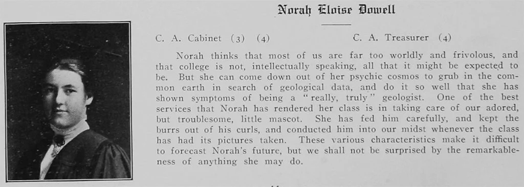
1913 Brown University yearbook
Unique among liquids, water is essentially unsquishable. Pressurize it, and water stays the same size—even if thousands of feet of dirt and rocks are piled on top of it. (That’s called lithostatic pressure.)
This property of incompressibility means that if you withdraw groundwater from the subterranean vaults it occupies, those spaces will collapse, causing the above surface to sink downward. (That’s called subsidence.)
A hydrogeological study published in 2016 showed that the mid-Atlantic coastal region of the United States is slumping, the result of excessive pumping of groundwater. Hydrogeologists identified Hyde County, North Carolina as the region’s fastest-sinking area, subsiding at a rate of more than one inch per year. Combined with a sea level rise of 4.5 inches per decade, the mass removal of water from under the ground will mean, warned the authors, more flooding on top of the ground.
Eight years later, a January 2024 study using satellite-based data collection showed that, in fact, the entire eastern seaboard, from Maine to Florida, is losing elevation. Extraction of groundwater is driving the trend. “The slow, gradual, and unapparent land sinking motion explains the lack of urgent policy interventions and subsidence governance. The resulting delayed response increases the exposure of coastal residents [to] the combined effect of sea-level rise and subsidence…. Subsidence increases the threat to coastal communities from sea-level rise and may even triple estimates of potential flooding areas over the next few decades.”
And another 2024 study that gathered data from 170,000 monitoring wells in 1,693 aquifers around the world found that groundwater levels are falling globally. Nearly one in three of the world’s aquifers show accelerating declines. These include aquifers in California’s Central Valley and in the southern and central High Plains of the United States.
In summarizing these findings in her story “Groundwater Levels Around the World are Dropping Quickly, Often at Accelerating Rates,” environmental journalist Liza Gross provided context: About half of all the world’s people draw their drinking water from underground aquifers. In the United States, 43 percent of us (143 million people) drink groundwater.
About 70 percent of the groundwater that’s pumped out of aquifers is used for irrigating crops, a task made more urgent by the growing unpredictability of rainfall in areas afflicted by climate change-fueled drought.
And more than 80 percent of the places where groundwater declines are accelerating have also experienced a reduction in total precipitation over the last 40 years, “hinting at a connection between climate variability and groundwater level change.”
In sum, we all greatly depend on water we can’t see. This dependency is predicted to grow as the climate crisis deepens. And yet groundwater is disappearing, and our communities are, as a result, sinking and therefore made more vulnerable to flooding.
And the hydrogeologists, who are still overwhelmingly men, are publishing all this but, despite their original mission to find water for the warhorses, are not riding in like the cavalry to save us.